
Creates cell objects using Coordinates from table columns. This function is similar to the Create Points function, but supports all object types.
The table needs at least three columns - for the X- and Y-Coordinate and a Cell-ID.
Set the table Mappable via Table Structure and chose the Projection which corresponds to the Coordinates stored in the table.
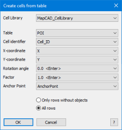
Cell Library : Name of the cell library containing the associated cells. How to create a library of cells is explained in Chapter Cell Style.
Table: Name of the table where the graphical objects are to be created.
Cell identifier: Name of the column containing the associated Cell-ID's (integer) or the Cell Names (string). It is recommended to use ID's because they are unique. For names, the uniqueness itself must be monitored because they can occur in several categories.
X-coordinate: Name of the column containing the X values (integer, decimal, float).
Y-coordinate: Name of the column containing the Y values (integer, decimal, float).
Rotation Angle (only with cartesian projections): Enter a fixed rotation value or choose a column containing the rotation values. When creating the objects are automatically rotated with the entered value. The values must be in degrees, counterclockwise. Types: integer, decimal, float.
Factor: Enter a fixed scale value or choose a column containing the scale values. When creating, the objects are automatically scaled with the entered value (2 = doubling, 0.5 = halving, and so on). Types: integer, decimal, float.
Anchor Point: Choose a fixed anchor point or a column containing the anchor points. The cells will be rotated and scaled around the anchor point. Type integer. Permissible values:
Fix anchor points |
1 Top Left |
2 Top Center |
3 Top Right |
4 Center Left |
5 Center Center |
6 Center Right |
7 Bottom Left |
8 Bottom Center |
9 Bottom Right |
Only rows without objects: Create only new objects for datasets without graphical object.
All rows: Overwrite all graphical objects.

•The popup controls list only columns with a valid data type. •The rotation angle is disabled for spherical projections because a rotation distorts the objects due to projection. •Point objects of type MapInfo 3.0 compatible and custom symbols are not rotatable (rotation angle <> 0 are ignored). •Point objects are not scalable (factor <> 1 are ignored) •The most accurate results are achieved when the projections of the target layer and the cell library match. It is also possible to use libraries from another projection. |
See also: Create Cell Cell Style Flanked Cells