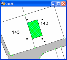
Using Snap to Line to align objects or clean overshots and undershots.
This function looks for all objects of a reference layer inside the digitizing tolerance radius and moves the node onto the line of the reference layer.
Supported object types: Line, Polyline, Polygon/Region, Rectangle
Result objects are polyline or region objects.
|
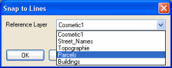
•Only the objects in the editable layer are processed. •The objects on the reference layer remain unchanged, except the add node option is activated. In this case, nodes are inserted in the reference layer objects where the objects of the target layer were snapped to. |

For first time using define the desired reference layer. All layers that are set to selectable will be provided. Enabling the Add Node option inserts nodes in the reference layer at the intersection. Later on you may change these settings in the main Settings-Dialog.
1.Select the object to be processed (it has to be in the editable layer).
2.Select the Snap to Line function
3.Click node by node to all nodes to be processed. The distance between the node on the target layer and the line on the reference layer must be smaller then the tolerance radius