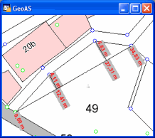
Generates measurement lines with cumulated distance and distance to objects.
|
•At least three nodes are required. •The labels are placed as real text objects (no auto labeling). |

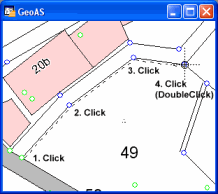
1.Select the Continous Dimension Line function.
2.Digitize the measurement line (for example based on existing points or objects such as parcel/house corners) and finish with a doubleclick.
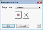
3.Choose the settings for the labeling and the target layer (the measurement line and the labels will be drawn in)