Splits region or polygon objects using a line or polyline.
Supported object types: Line, Polyline, Arc, Polygon/Region, Ellipse, Rectangle, Rounded Rectangle, Collection
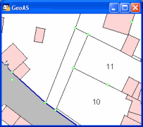
Result objects are polyline or region objects.
|
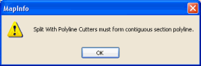
•Be aware that you have to start and end on the edge of or outside of the selected area. If not, the "Splitting Line" extends in the oppsite direction. •Use the snap mode to snap to existing nodes. •Avoid splitting lines with self-intersection. Otherwise the following dialog box displays:
|

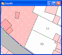
1.Select the region or polyline object you want to split. (The target object must be on the currently editable layer.)
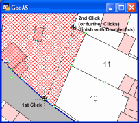
2.Select the Split Region using Polyline function. (The shape of the cursor changes to a crosshair cursor.)
3.Digitize the desired line clicking on the left mouse button for each node.
4.Doubleclick to apply the splitting functionality.