
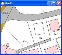
Creates a rotated rectangle using specific width and height.
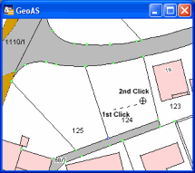
1.Select the Rotated Rectangle function. (The shape of the cursor changes to a crosshair cursor.)
2.Digitize a construction line to define the direction/bearing.
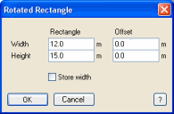
3.Define the width and height. The width is calculated from the length of the virtual line and can be modified. The height can be typed in and will be kept.
Optionally, you can enter an offset (Width for line direction, Height for line direction left sided). For Store width the width can be buffered.
|
The cosmetic layer is not supported! |
