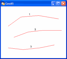
Creates polylines from database columns. Both the whole table and a single selection can be edited.
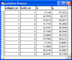
The table needs at least three columns:
•Two columns must contain numeric coordinate values.
•The third column contains a key indicating the datasets belonging together.
•A fourth optional column can define the polygon node sequence (node number). When using node numbers, they have to be clearly assignable to avoid incorrect results from double entries. Furthermore, when using node numbers they have to be assigned for all polygons. If node assignment is not applied, the key column will be declared as node number. In this case, datasets will be processed and assigned sequentially.
You need at least two datasets per key to create a polygon. Datasets with values=0 will be ignored.
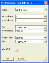
1.Select the Polyline from Table function.
2.Choose a table or selection containing the coordinate list you like to create polyline objects from.
3.Enter the columns for the X- and Y-coordinate values. Choose the column containing the key (and thus containing the assignment information of the datasets for the single polygons) below. Details about the node number are optional - choose a column declaring the dataset order here.
4.Choose a mappable Target Layer and enter the column, where the particular key of the source table has to be registered.