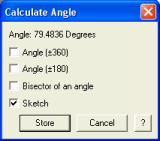
An angle is the difference between two directions. This function returns the value of the angle between two straight lines segments.
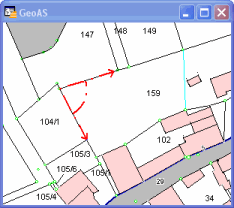
The calculated angle depends on the sequence of the selected lines (counter-clockwise). Additionally, the calculated angles can be sketched in the map window. The sketch disappears with the dialog.
Supported object types: Line, Polyline, Polygon/Region, Rectangle, Collection
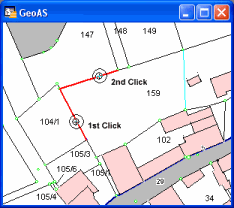
1.Select the Calculate Angle function. (The shape of the cursor changes to a crosshair cursor.)
2.Select the first line, select the second line.
Sketch: Generates a sketch.
Optionally, you can choose the complementary angle (+/- 360 degrees), add/substract (+/- 180 degrees) or determine the bisector of the angle.
Click Store to store the angle variable for later use (e.g. Polar Append, Move and Rotate.).