![]() With the GeoTracker, the current position of the computer or mobile device can be displayed and continuously recorded. (It's a separate Tool, not included in ToolPad)
With the GeoTracker, the current position of the computer or mobile device can be displayed and continuously recorded. (It's a separate Tool, not included in ToolPad)
Requirements
•The device needs the Operating system Windows 10 or higher and a GPS interface (Windows API)
•Granted access to the location. (System Control->Data Protection->Position)
•MapInfo Pro Version 17 or higher
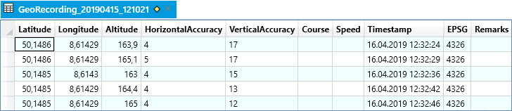
The coordinates determined by the GPS are in Lat / Long and will be stored in a native MapInfo table, which is created automatically the first time. The table is namend GeoRecording and is provided with a date and time stamp.
Example: GeoRecording_20190415_121021.tab (created on 04/15/2019 at 12:10 pm)
 Options
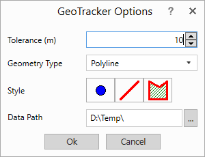
The Tolerance determines from which distance movement a new position is recorded.
The Geometry Type defines whether points, polylines or surfaces are recorded. For each type of geometry a Style can be defined.
If no table is open for recording, a table is created in the Data Path when the recording is started.
Center
The current position of the device is displayed in the active map window with a transparent position circle. The diameter of the circle indicates the current accuracy of the GPS signal. The smaller the diameter, the more accurate the measurement. When the device moves, the position circle is automatically moved. This function can also be used without a recording.
 Record
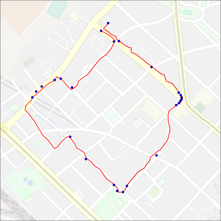
When the recording is started, the position of the device is recorded dynamic in the GeoRecording table. Points, lines and polylines are displayed directly in the map window. For regions, the polygon is closed when the recording is ended.
With the geometry types point and line, a separate data record is created for each capture point. These object types are suitable for recordings that are to be processed analytically.
For polylines and polygons, another node is inserted into the same object for each capture point. At the end of the recording, only a single record is created. These object types are suitable if few data records are desired and the coordinates of the individual nodes are not needed.
 Stop
Stop
Stops the recording. To show the recorded rows open a browser window for the GeoRecording Table.
 Record Point
This function is used to capture single positions. Each time the button is pressed, the current position is recorded in the GeoRecording table.
 GPS Info
The current GPS position and the accuracy of the measurement are displayed in a dialog.
see also Technical Requirements